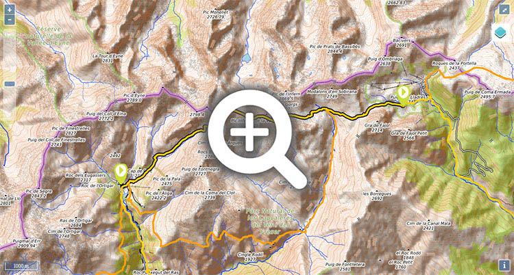
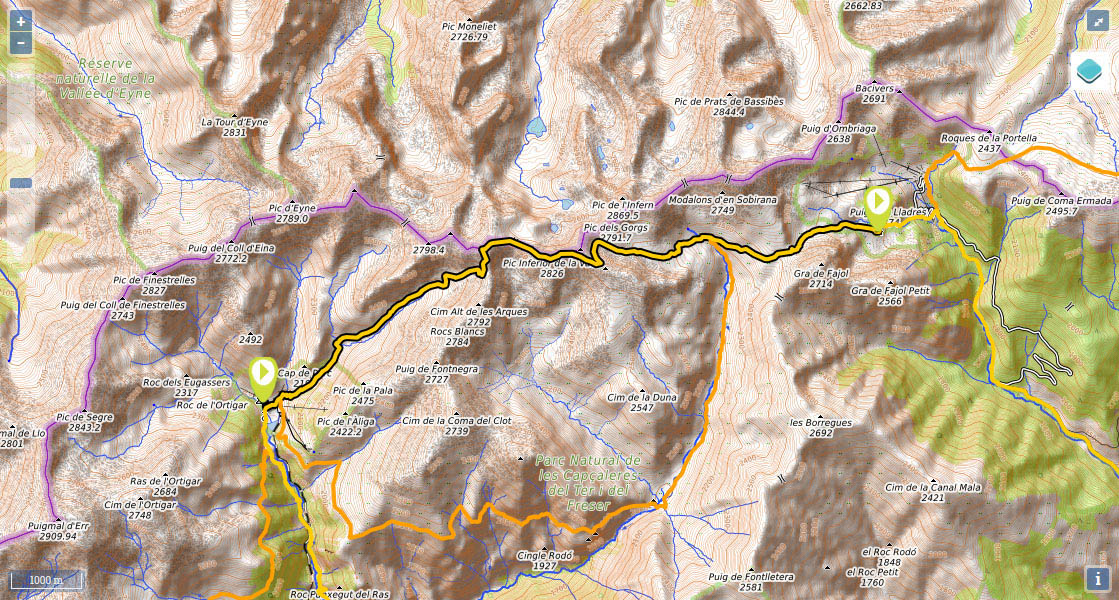
Stage 38: Santuario de Nuria - Refugio de Ulldeter

(0h00min; 0 kms) Santuario de Nuria (1.967m). Walk round the back of the temple, pass a meteorological observatory and cross a small bridge over the Noufonts torrent. You head right, to join the track rising up the valley, that leads to the Noucreus and Noufonts cols. The track gives way to a path and you soon see the spot where the Noucreus and Noufonts torrents converge. Cross Noucreus torrent via the Pont de L'Escuder bridge and you will quickly come to a crossing.
(0h40min; 1,8 kms) Cruce Noucreus-Noufonts (2.180m). Although in many (older) publications the GR11 route is still indicated as passing through Noufonts, in current times the red and white markings direct you to Noucreus col, a quicker and more direct option. Keep climbing the path to the right that heads up through Noucreus valley passing La Coma de les Molleres and La Coma de Noucreus. Towards the end of this section, the climb gets steeper, you reach the col with panoramic views and turn left in order to reach Noucreus col in about 5-10 minutes.
(2h15min; 4,8 kms) Collado de Noucreus (2.790m). You join the ARP route (unmarked). From this point, the walk follows the ridge that marks the frontier, between peaks of around 2,800m. Pass the Pic de la Fossa del Gegant (2,808m) by the north face and drop down to Carança col (2,726m), then continue up to Pic Inferior de la Vaca (2,826m), past Coll de la Vaca (2,793m) and leave the Pic Superior de la Vaca (2,820m) on the left, to continue along the border ridge to...
(3h05min; 6,6 kms) Collado de Tirapits (2.775m). Turn left (north-west) and begin the descent. After 10 minutes you pass Barraca de Tirapits shelter (only in case of extreme necessity). Continue down through the valley, leaving the Torrent de Les Barraques on the right, until, in a relatively flat area, you rejoin the GR11.7 variant coming from Nuria. At this point you cross a stream that appears on the left, and start the climb to the...
(4h15min; 10,1 kms) Collado de la Marrana (2.524m). Wide open view. The walk drops sharply through the small cirque, then you continue your descent across the valley floor, crossing a ski piste, until you reach the...
(5h00min; 11,6 kms) Refugio de Ulldeter (2.220m).
At the beginning of the stage you have the Refugio-Albergue Pic de l'Àliga and the Hotel Vall de Nuria. There is also a controlled camping area ()
During the stage you will pass by the Barraca de Tirapits shelter. This is not really an option – only in case of extreme necessity.
At the end of the stage, Refugio de Ulldeter (/).


Zona de acampada en Nuria

Abajo Nuria

Lugar donde confluyen los torrentes Noufonts y Noucreus

Marmotas jugando.

Camí Carener - Conca de Noucreus

Subiendo al Coll de Noucreus


Bajando al col de Carança con el Pico de l'Infern de fondo


Llegando al col de la Marrana. El GR11 viene por el valle que queda detrás.